Thursday, March 7, 2013

Routeburn Track Photos

We hiked for a day on the Routeburn track, basing ourselves at the Sylvan DOC campsite, nearby. This campsite is situated down a rough gravel road north of Glenorchy. Glenorchy is at the end of the lake on which Queenstown is located (Wakatipu) and the drive between the two towns is very scenic.


Miiner's cottages at Arrowtown, a charming but touristy small town we passed through en route to Queenstown

Bridge in park in Queenstown. This park was an oasis in an otherwise frenetic city. Queenstown is the base for tourism in both Fiordland and the Queensland Lakes area.

Look off on the drive towards Glenorchy from Queenstown

We began our hike at crack of dawn, because we intended to do the equivalent of two days hiking in one day. All told we hiked for more than 9 hours, with a couple of hours rest along the way, returning at 7 pm.

Routeburn falls lie just above the large hut (48 bunks) and an even larger luxury lodge for guided walkers.

Harris lake lies just below Harris saddle, which was our halfway point on the track.

Some absolutely massive rocks had fallen from the cliffs above the trail.

Shelter and guided walker's rest stop on Harris Saddle. Low clouds/fog came and went in this area.

Looking down on Harris shelter. We climbed Conical Hill above the saddle for some great views, leaving a backpack at the shelter. 

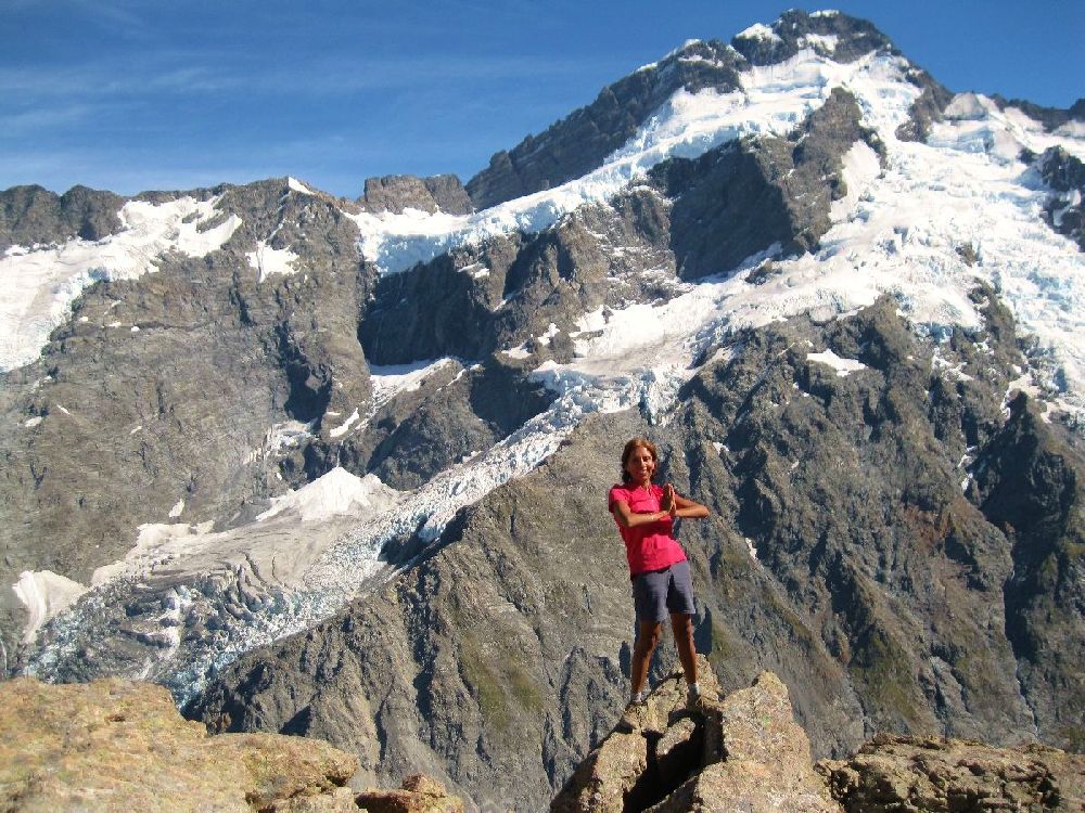
View from Conical Hill - our turnaround point on this hike.

There were a few good photographers on the peak, so we took the opportunity for a couples shot,

360 degree views on Conical Hill

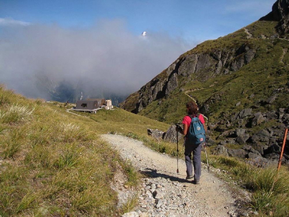
I demonstrate the use of hiking poles above Harris Lake. We have found a single pole quite useful on some of the more scrambly walks.

Lunch spot at Harris Saddle

Giant daisies

Wind swept lookout over Routeburn Flats with the Falls hut and lodge below.

Cows graze in the field at the Sylvan DOC campsite

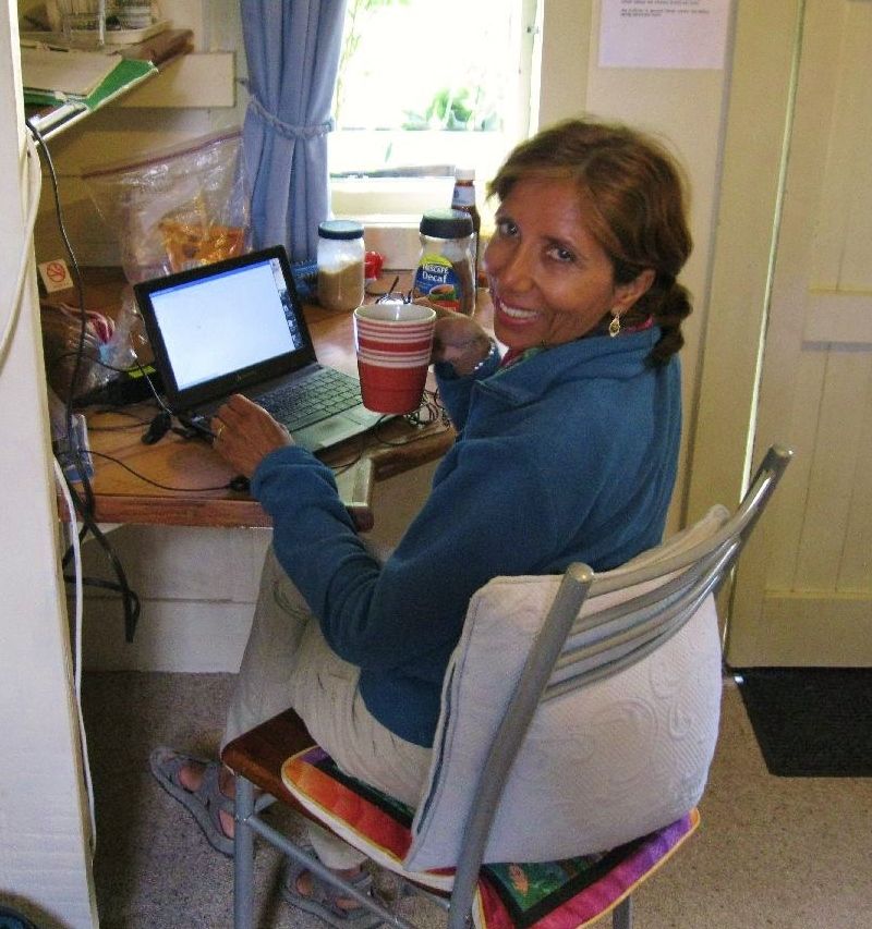
We are now in Kingston, just south of Queenstown, catching up on emails and doing pharmacy  training.

Our little cottage at Hector's Holiday Camp in Kingston - home for two lovely relaxed days.

Today we leave for Te Anau and the start of the Keppler Track. We will miss Kingston and have enjoyed our stay here at Hector's. I recommend 'The Cottage' as a great little, relatively inexpensive ($60/night) option for campers wanting to get off the ground for a night or two! We have booked a hut on the Keppler track for tomorrow night (54 dollars each!) because we have heard that the scenery on the ridge above the hut is amazing and there is no way to reach it on a day hike.

Photos from Christchurch and the Banks Peninsula

This post is out of order, because we visited Christchurch and the Banks Peninsula a couple of weeks ago, but better late than never. Please see earlier post for more details on our trip to the Banks Peninsula.

Rani and friend in the botanical gardens, Christchurch

Amazing topiary at the botanical gardens

The rose garden features some surprising hybrids.
The trees are also pretty large in this park - Rani stands under a grand old eucalyptus.
We took in part of a play adaptation of Wind in the Willows in Christchurch and then hurried off to find a campsite.

From Christchurch we made our way to Orton Bradley park where we did some hiking and met Bill Sykes, who volunteers in the gardens (see earlier post).

Rani with horticultural expert Bill Sykes


The Orton Bradley park features a water driven lumber mill and we came across this elderly pump engine about a kilometer from the mill.

A whimsical door in the woods

View back toward Orton Bradley park en route to Mount Herbert (920 meters)

We made our own route on the way up, passing through pastures.

These sheep seemed surprised to see us.

There is a shelter on the way up Mount Herbert

On the way down - Mount Bradley in the distance

Lovely views on the way back to Orton Bradley Park

Much of the trail is through meadows

After Orton Bradley, we drove over to Okains Bay and camped there at a lovely and well equipped campsite on the beach.

Library in Okains Bay has been running since the 1860's - The building is only about 5 meters by 5 meters and contains one wall of books, and a large round table  and chairs where books used to be read to those who could not read.

Colourful and shapely phone booth in Okains Bay. We saw a similar booth in far away Arrowtown, this week.

Sheep herding, using ATV, small boy, and dog


Chicken at campsite in Okains Bay - came looking for a hand-out. She likes crackers and cooked oatmeal (no raw oats please).

Rani has a cracker

Quite a jump for such a plump little bird.

Baby booties at a stall in Akaroa


Classic car tours were a common site in Akaroa


Tuesday, March 5, 2013

Pictures from Lake Pukaki and Mount Cook Hikes

We traveled toward Mount Cook via lake Tekapo and lake Pukaki. The colour of these lakes is a remarkable swimming pool blue and they provide a startling contrast to the hills and mountains among which they are set.

Lake Tekapo

Church of the Good Shepherd on lake Tekapo

View through the picture window behind the church alter. I would find this a bit distracting as a parishioner.


View back to Lake Tekapo from the Mount John observatory. The skies here are very black and the town has specially hooded street lamps to reduce any glare.

We 'freedom' camped on lake Pukaki in a little spot just off a bicycle path. Whenever we do this type of camping we make sure to leave the place cleaner than we found it. This site was not heavily used because it required us to walk in, but I still bagged a full grocery bag of discarded cans, bottles, and toilet paper - delightful.

The lake water was a bit chilly, but we went for a dip anyway.

Walking along the bicycle path beside Lake Pukaki

Morning view from our tent

Driving along the shore of Lake Pukaki en route to Mount Cook park.

Check out this picture by Trey Ratcliff taken in the same area - WOW.

We camped at the DOC campsite in the Mount Cook park and went on a hike the next day out to Hooker lake through the Hooker Valley. The walk is easy and the views are stunning for most of the route.

Monument to climbers lost in this area

Rani never misses an opportunity to have our picture taken together.


There are three suspension bridges on the trail - one currently under construction.

Rani crosses one of the beautifully built suspension bridges. The materials were flown in by helicopter and we saw a load being transported this way the morning after our walk.

The trail has walk ways across more sensitive areas.

With views like this who can blame Rani for skipping along?

The trail follows this river bed to the lake

Hooker Lake is a trifle chilly - yes those are ice bergs behind as the glacier was actively calving.
This shelter lies on the trail about 2/3rds of  the way to the lake


Nice view from the shelter's window of Mount Cook.


Next morning we awoke to another fine day. A near full moon competes with the low sun. 

We set off for the Mueller hut quite early, reaching this view at Kea Point around 8 am. This is a huge lateral moraine left by the Mueller glacier (Mount Cook behind). We saw photos of this area completely under ice only 100 years ago.

There are 1810 steps to the Sealy Tarns rest point, which is about half way up to the Mueller hut. The rest of the ascent is of similar steepness but without the steps. DOC has done a great job on these steps - even and well secured.

View of the glaciers in one of the Sealy Tarns

Rani poses at a lookoff en route to the Mueller Hut

We met Ryan, and American from Rochester, NY at the lookoff.

Chris and Ryan hike near some leftover snow on the approaches to the hut 

Mueller hut - rebuilt recently and now quite large and well insulated.

Rani leading a scramble up Mount Olivier, above the Mueller hut.

View from Mount Olivier toward Mount Cook. Hooker lake lies below.

Nicolai, a Russian guide and former weather router for long range soviet military aircraft. You meet the most interesting people on a mountain side.

Bunks in the hut

Views from the deck are quite fine

The hut has gas stoves, but this year there was a problem with water and they were melting snow.

Even up here at nearly 2000 meters there is ample life

Rani making a snow angel

A picnic table with a view - Sealy Tarns rest stop on the way down.

We highly recommend the hike to Mueller hut and Mount Olivier. If you do go, please try to stay on the rocky parts of the upper trail because there are large erosion problems with many side paths being caused by new trail blazing.

Many have gone before. This woman was one of the pioneers in mountaineering in this area. I find this photo (from the late 19th century) disconcerting because it appears that she has amputated her guide's left leg with her ice axe.

The excellent Mount Cook Village visitor's center features two lovely stained glass windows of local wildlife including this Kea or alpine parrot. We later saw a flock of these parrots on the Routeburn Track.

There is a larger than life statue of Rani's hero, Sir Edmund Hillary, at the cafe in the Hermitage hotel.

Hillary cut his teeth on mountains in this area and this photo shows him on a fairly recent visit to Mount Cook village.

Hillary seems to look toward Mount Cook.