Tuesday, March 5, 2013

Pictures from Lake Pukaki and Mount Cook Hikes

We traveled toward Mount Cook via lake Tekapo and lake Pukaki. The colour of these lakes is a remarkable swimming pool blue and they provide a startling contrast to the hills and mountains among which they are set.

Lake Tekapo

Church of the Good Shepherd on lake Tekapo

View through the picture window behind the church alter. I would find this a bit distracting as a parishioner.


View back to Lake Tekapo from the Mount John observatory. The skies here are very black and the town has specially hooded street lamps to reduce any glare.

We 'freedom' camped on lake Pukaki in a little spot just off a bicycle path. Whenever we do this type of camping we make sure to leave the place cleaner than we found it. This site was not heavily used because it required us to walk in, but I still bagged a full grocery bag of discarded cans, bottles, and toilet paper - delightful.

The lake water was a bit chilly, but we went for a dip anyway.

Walking along the bicycle path beside Lake Pukaki

Morning view from our tent

Driving along the shore of Lake Pukaki en route to Mount Cook park.

Check out this picture by Trey Ratcliff taken in the same area - WOW.

We camped at the DOC campsite in the Mount Cook park and went on a hike the next day out to Hooker lake through the Hooker Valley. The walk is easy and the views are stunning for most of the route.

Monument to climbers lost in this area

Rani never misses an opportunity to have our picture taken together.


There are three suspension bridges on the trail - one currently under construction.

Rani crosses one of the beautifully built suspension bridges. The materials were flown in by helicopter and we saw a load being transported this way the morning after our walk.

The trail has walk ways across more sensitive areas.

With views like this who can blame Rani for skipping along?

The trail follows this river bed to the lake

Hooker Lake is a trifle chilly - yes those are ice bergs behind as the glacier was actively calving.
This shelter lies on the trail about 2/3rds of  the way to the lake


Nice view from the shelter's window of Mount Cook.


Next morning we awoke to another fine day. A near full moon competes with the low sun. 

We set off for the Mueller hut quite early, reaching this view at Kea Point around 8 am. This is a huge lateral moraine left by the Mueller glacier (Mount Cook behind). We saw photos of this area completely under ice only 100 years ago.

There are 1810 steps to the Sealy Tarns rest point, which is about half way up to the Mueller hut. The rest of the ascent is of similar steepness but without the steps. DOC has done a great job on these steps - even and well secured.

View of the glaciers in one of the Sealy Tarns

Rani poses at a lookoff en route to the Mueller Hut

We met Ryan, and American from Rochester, NY at the lookoff.

Chris and Ryan hike near some leftover snow on the approaches to the hut 

Mueller hut - rebuilt recently and now quite large and well insulated.

Rani leading a scramble up Mount Olivier, above the Mueller hut.

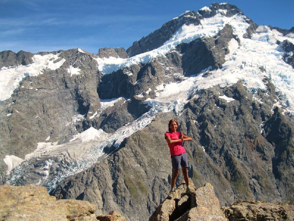
View from Mount Olivier toward Mount Cook. Hooker lake lies below.

Nicolai, a Russian guide and former weather router for long range soviet military aircraft. You meet the most interesting people on a mountain side.

Bunks in the hut

Views from the deck are quite fine

The hut has gas stoves, but this year there was a problem with water and they were melting snow.

Even up here at nearly 2000 meters there is ample life

Rani making a snow angel

A picnic table with a view - Sealy Tarns rest stop on the way down.

We highly recommend the hike to Mueller hut and Mount Olivier. If you do go, please try to stay on the rocky parts of the upper trail because there are large erosion problems with many side paths being caused by new trail blazing.

Many have gone before. This woman was one of the pioneers in mountaineering in this area. I find this photo (from the late 19th century) disconcerting because it appears that she has amputated her guide's left leg with her ice axe.

The excellent Mount Cook Village visitor's center features two lovely stained glass windows of local wildlife including this Kea or alpine parrot. We later saw a flock of these parrots on the Routeburn Track.

There is a larger than life statue of Rani's hero, Sir Edmund Hillary, at the cafe in the Hermitage hotel.

Hillary cut his teeth on mountains in this area and this photo shows him on a fairly recent visit to Mount Cook village.

Hillary seems to look toward Mount Cook.

From Christchurch to Mount Cook


Note this was written offline a week ago... Just back within internet range now.


We are camped on the shore of Lake Pukaki with views across the lake to the tallest peak in the country, Mount Cook. We are 'freedom camping' - that is we are not paying for a site, but are camped on public land. Some of our most lovely sites on this trip have been of this variety, with one on a glorious beach, under a pine canopy, and another beside a river near Lake Taupo. Freedom camping used to be much more common in New Zealand and is still possible in many areas away from towns.


Since our last post, we have continued south, visiting Christchurch where Chris put in an application to renew his visa. This turned out to be a pain and quite an expense - not the rubber stamping exercise we had been lead to expect. Cost - over two hundred US dollars - time to process - twenty five days - need proof of sufficient funds - one thousand NZ dollars a month plus 2 passport pics plus proof he will leave plus a NZ address to mail the visa and passport back to. Ughh!!  Suggestion for NZ immigration - most sailors will stay 6 months due to having to sit out cyclone season. Most of us have every intention of leaving and ample cash to tide us over here. So why not issue 6 month visas to all visiting sailors? We would even let you see a bank statement, if that helped!

We only spent a brief time in Christchurch, so cannot comment on how the rebuilding is going except to note that getting cheap accommodations in or near the city is nearly impossible due to all the workers who have come here to help rebuild the city and are living in campgrounds and hostels and out of trailers while they are here. I have never seen so many no vacancy signs. One local told us that they are still bringing down buildings damaged in the quakes and that reconstruction is just beginning. On a positive note, there is a strong movement to take this opportunity to rebuild a very livable city with green spaces and walk-ways.

The Banks peninsula projects into the ocean to the east of Christchurch. Mostly hilly, it is a lovely place to visit and we spent a most enjoyable few days hiking and exploring historic villages. Particularly recommended is Orton Bradley park from which you can hike the tallest hill on the peninsula [Mt Herbert at about three thousand feet]. This park was an experimental farm in the 19th and early 20th centuries. In its fascinating gardens we met a horticulturalist, named Bill Sykes, who had spent a good part of his life exploring the world looking for new species of plants. He has been to the Himalayas on various expeditions around the time that Hillary was climbing Everest and had even met the great climber quite recently, while they were both in the Himalayas. Bill showed us a plant that was from Juan Fernandez Island, where Crusoe [or his real-world model, Selkirk] was marooned. The common name for the plant is Robinson Crusoe's Cabbage - and it does resemble a cabbage on the end of a long trunk. Bill was excited because this plant was flowering for the first time since he had planted it several years ago.

We also visited Okains Bay - a tiny village in a valley off the Summit Road that runs along the peninsula. The drive down into the valley was hair-raising, even in a small car, and I had to use low gears to save the brakes. At the end of the road is a peaceful oceanfront campsite with forested sites and a long gradually sloping beach. Many trailers and tents were set up when we arrived, but were vacant. We learned that people from Christchurch leave their camps set up from weekend to weekend through the summer and pay a nominal fee for this. An interesting alternative to a summer cottage.

From Okains Bay we drove into Akaroa. This historic little town was at one time a center for fishing and farming, but is now a stop on the cruise ship routes. Two ships were in the harbour when we rolled into town. The streets were chock full of wandering tourists, despite dozens of busloads already departed for tours elsewhere. The poor little town groaned under the load and, while I am sure it is a charming place out of season, I did not feel it was worth visiting on the day we arrived.

We are now finally on our way into the Southern Alps and will set up camp near Mt. Cook tomorrow to do some day hiking. I have lined up some short hikes and a long day hike to the Mueller Hut, which promises splendid views of Mt. Cook and the neighboring peaks.

Wednesday, February 20, 2013

Pictures from South Island camping and hiking

Cicadas are everywhere we have hiked. They make such a din that at times one is tempted to cover one's ears.

A typical vineyard planting close to Blenheim

On the 12 km twisty gravel road to the Sawcut Gorge hike.  Ure River down in the valley 

Chris rock-hopping in Sawcut Gorge - the hike requires you to walk up a river bed, making frequent crossings.

Freedom camping on a beach

Enjoying the view of turquoise water and golden hills 

Kelp and castle-like rock outcroppings  


A fur seal sunning itself
Lovely clear fresh-water pool for a cool bath in the privacy of a deserted beach

Wellington and ferry to Picton

Wellington is where one catches the ferry to the south island. Our ferry was cancelled due to engine problems, so we had a few hours to spend before we boarded the competitor's (InterIslander) ferry.


Rani at the parliamentary library in Wellington

Not my cup of tea, but the 'Bee Hive' is the executive wing of New Zealand's parliament.

NZ parliament's library

InterIslander ferry arriving in Wellington

View from deck entering Marlborough Sound

Rani met Shashi and her husband in the ferry line-up. They are from a village close to where Rani's Mum lived in Punjab. 

In Marlborough Sound.

Approaching Picton where the ferry docks.

Cape Palliser lighthouse and fur seals

This post is dedicated to my friend Chris Mills, a former lighthouse keeper living in Ketch Harbour, Nova Scotia. Chris loves all things related to light keeping and lighthouses and has written some great books on the subject.

Cape Palliser light - reached by 250+ steps. It still sports an 1897 Fresnel lantern.

Bulldozers are used to launch and retrieve fishing boats on the loose shingle beach nearby.

Rani on the long climb to the light

Light detail - note the cast iron frames, lovely copper(?) dome, and Fresnel lens

Just down the road is a colony of fur seals.

These baby fur seals appeared to be quite unconcerned with us.

Pinnacles

Near Cape Palliser on the south end of the North Island, we camped adjacent to an area of Hoo-doos or pinnacles. 


This was all seabed, which has been eroded into towers and buttreses

We found partially fossilized tree trunks eroding in one gully. The centers of these ancient trees have been mineralized while the outsides are still tree.

Rani scrambles among the pinnacles

We also came across layers of burned wood that had also been compressed under dozens of meters of rock and was now incredibly dense and rock-like. 

Rani sprouts a new pair of wings.

Huts, Loos, and Churches

I have always enjoyed seeing how building is done in different cultures. Here are a few pictures from along the way during our north island travels.
 
Rani inspects the bunk arrangements in the Blue Range Hut.

Most tramping huts have wood heat/cooking. Gas appliances have been recently removed.

A very BLUE hut.

Hut builders have a sense of humour, given that this hut is at the end of a 2-3 hour hike along a narrow and steep trail. Note the small cistern to collect and store roof run-off.

We have stayed in a mix of Dept of Conservation campgrounds and 'freedom campsites', where one camps for free. This site had a fantastic picnic table made from old growth wood. The top is one piece nearly 1.5 meters (5 feet) wide.


Our own piece of architecture - a 45 dollar dome tent that bends alarmingly in any sort of wind, but has kept us dry for two nights of rainy weather to date.

We found this classic iron paneled loo in one of the towns we passed through.

Modern stainless urinals but with elegant shadows cast by piercings in the panels.


I did not have a dress on, so no need to adjust :)

Immediately opposite the antique convenience is a completely automated touch free loo, complete with musac ('What the world needs now is love...')

Burnside church